Thursday night- We drove 2-1/2 hours and car camped at Suttle Lake, about 15 miles from Sisters, Or. I drank way too many beers, slept in, and got a later start than expected. But it's vacation, can't feel too guilty.
Day 1- Sisters
From Suttle Lake campground, we drove into Sisters, parked the car, packed the bikes, and rolled over to Sisters Coffee Company for breakfast. Things always taste better when you're camping, but their coffee is exceptionally good.

The first 2-miles of pavement out of town was already scenic

Red dirt is typical of the dry side.

Within 8 miles, we veered off (our intended) course and into some bush whack.
 Not to be deterred, we pushed through what ended up being nearly 1/2 mile of uphill hike-a-bike to the next road. Totally worth it.
We popped out on a nice road through a burned out area. I'd guess it happened 10 years ago, based on the new trees and underbrush. It made for a spectacular scene with the new green, the old dead trees and vivid blue sky.


 I ended up with about 30 photos that looked exactly like this...
 ...and this
 Stop, eat, drink, look at maps, high five, carry on
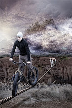
If you've read this blog before, you've heard me say mountain bikes are the only way to go for loaded off-road touring. This section is one of many we encountered that was quite rough for a 55-pound bike. Even the smooth looking road sections were rougher than the camera shows and softer than skinny 700 x 45 tires would allow. I asked Donnie if given the choice between a Pugsley and a 700x45 cross bike on these trails, he'd take the Pug. Me too.

At the end of the day, we each had less than 5 miles left in our legs. Seconds after Donnie suggested we check this little roadside campsite out, we knew it was home for the night. Wychus Creek provided fresh water, a cold bath and a lulling noise throughout the night. While sitting around the fire eating dinner, a big grey fox trotted within 100 feet of our campsite, seemingly without regard for us. It was the only real wildlife we'd encounter for the rest of the trip.
Day 2- Whychus Creek to Tumalo Creek
When you're back country bike touring, you don't always have the luxury of stopping into a town to fill up with water. You have to read your maps, look for creeks/streams, carry purification tablets/filters/Steri-Pen and make sure you have enough water in between sources. Donnie carried 3 full-sized waterbottles with a back up 250-ml dromedary bag, while I had two small bottles and 250ml dromedary bag.

Day 2 started with climbing out of the Whychus Creek valley. Just when you thought the views weren't going to get better than they were on day 1, you stop and turn around to see this. Fuck!

Highway 16 turned out to be a monstrous 6-mile paved climb. Each time you thought you were nearing the top, it went up again. Finally, with gravel in sight, the road topped out near the Three Creeks Recreational area.

Always a master a good suggestions, Donnie thought to stop at a roadside creek, fill up with water, and take another swim. While sitting on the side of the road, a small truck pulled up, the driver rolled his window down and said "I'm gonna make you boys an offer you can't refuse"
Being that we'd been talking about beer for two days, I sarcastically replied "what, do you have some beer in the back of that truck?"
In fact, he pulled out two cans, and they had ice on top of them, and they weren't Coors Light (which I would've kindly taken, BTW). Nope, it was a Caldera Pale Ale. While normally a damned fine beer, this can of beer stands as the best single can of beer I've drank in 2011. Cheers, brothers, whoever you were!


From Three Creeks and the best beer of the year, we continued to climb a bit more towards the highest point of our three-day ride, just under 7,000 feet elevation. As half-expected, we hit snow on the road

It was only a 1/4 mile, but we pushed our bikes through the snow as fast as we could so the mosquitoes didn't eat us alive.

We opted to divert from the trail to check out Tumalo Falls, and it was almost all downhill to there. Shortly after taking this picture of Donnie, I hit 40.3 mph, which is quite sketchy riding loaded bike on gravel. I've never been so happy to have the trusty Karate Monkey under me.

Yet another great high-speed straightaway
 Finally to Tumalo Falls, and well worth the side trip. We ran across the race course of the High Cascade 100 MTB race, got some support from the course marshals and took a much needed 90-minute break from riding. Naturally, the break included a wash in the creek.
While leaving Tumalo Falls, we were going to ride the paved road for a bit to expedite the spot where we thought we'd camp for the night. But a local rode by as we were pumping our tires up, and gave us a stellar recommendation to go back on the road by Tumalo Creek to hit an old abandoned canal road.

Much like the kindness of the beer bearing dudes earlier in the day, his advice was exactly what we needed. A 10 minute ride of gradual gravel led us to this spot on Tumalo Creek. The canal had been built to supply water for Bend, Oregon, but the reservoir apparently didn't hold water. Nice. Made for as good of a campsite as we had the night before.
 The remains of the canal diversion made for a good spot for a tent
 Thanksgiving dinner! Stove Top stuffing mix, dried potato flakes, dehydrated turkey slices, dried cranberries and just-add-water turkey gravy. Quite good. Next time I'll add dehydrated corn.
Day 3- Waking up early, I made extra coffee and walked down the dried up canal, thinking how sweet this would be for a future fat bike ride.

The abandoned road along side the canal was flat and slightly downhill. With how much climbing we'd done on the trip so far, we were happy to have some flat grades to pedal on.
 After the canal road, we hit some singletrack, saw some random mountain bikers, stopped at a natural freshwater spring, and got to old railroad grade road 4606 that would take us most of the way back to Sisters. 4606 was flat, slightly downhill and considerably more exposed to the sun than we had on the prior days.
Almost to Sisters, where we could finally eat the BBQ and pie we had thought about for the last 3 days

Pulled pork and a cold Hamms. Spectacular.

Marionberry cobbler. Yum.
Overall, it was the best trip of the summer. If you're planning on touring the dry side of the Cascades via dirt, I strongly recommend the following:
- A mountain bike with fat tires
- More than one series of maps
- In addition to maps, a GPS with downloaded topo maps was really handy
- Capacity to carry a bunch of water
- Go light, your body and your bike will appreciate not having to haul excessively heavy touring gear
If you want to follow our route- GPS coordinates can be found here